"People are feeling seen and heard, and we're providing solutions that they feel they have contributed to"
Through November and December, Transpower & Altavec have helicopters equipped with laser technology flying the length of New Zealand to survey our transmission network.
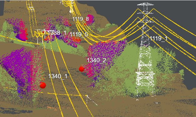
The laser surveys (known as LiDAR) capture millions of data points which come together to show a highly precise 3D view of the surveyed area and assets. We're carrying out this work so that we can have accurate digital information models, as well as highlighting areas where vegetation is too close (or risks becoming too close) to our assets and could pose potential risks.
"Thanks to the great team at Altavec for carrying out this aerial capture for us!"
It's a new and innovative way in our approach to vegetation management, and we're looking forward to putting this data to great use.
Thanks to the great team at Altavec for carrying out this aerial capture for us!
"People are feeling seen and heard, and we're providing solutions that they feel they have contributed to"
“The investment we made will pay dividends for years to come. They not only met their obligations, but exceeded our expectations”
"Thanks to the great team at Altavec for carrying out this aerial capture for us"
Get in touch wth our dedicated team of experts today and experience the Altavec Advantage